Thursday, June 17, 2010

WATER WATER EVERYWHERE

North Carolina is wet.  Rivers, lakes, waterfalls, rain.  We continued south on the Parkway to Linville Falls, where we put up for a couple of nights at Secluded Valley Campground, which was just as idyllic as it sounds.  Well back along its own access road, the sites are arrayed around a central pond, with good shade trees and well-spaced.  The view out our back window:

IMG_2836

We scooted along the river on the way to Linville Falls and the Linville Caverns.IMG_2838

Really, almost the entire state looks like this.  Coming from L.A., this was nature overload at its best.  The Falls is an upper and lower pair, with an abrupt chute that produces a pretty good roar.  We almost had the

Southeast Trip M-J 201010

place to ourselves, but a fellow hiker was there to take our pic.  We’re not wearing long sleeves because it’s cold:  it was very hot and humid, but the sleeves kept the sun and the bugs off.  The next stop was Linville Caverns,IMG_2851 one of the few “wet” caverns that are still forming active stalagmites and stalactites.  It’s not very big,IMG_2855 no grand rooms or anything, but the guide was amusing and it had some interesting stuff, like the blind trout (look close) IMG_2852

the five foot sloppy tongue (the green thing at left) IMG_2857

and some icy formations.  It was no Carlsbad, but it  IMG_2859

was nice to get underground out of the heat.  Next stop was Crabtree Falls, which were beautiful, and provided IMG_2869

a nice artsy-craftsy opportunity:

IMG_2864    

After all this hiking, it was past time for some lunch, so we looked around for a likely spot.  The town of Little Switzerland sounded good, and we lucked onto a gem, the Little Switzerland Cafe.  We don’t know what top-flight chef has taken refuge here, but this was a realIMG_2873

find.  Loni had a smoked trout BLT on a real croissant, and I had a pulled pork barbeque sandwich topped with cole slaw on a bun.  Both were terrific.  We were totally full, but the dessert cooler was outstanding.  We had to have a raspberry chocolate torte and a lemon cream pie.  El bloato, but grinning all the way back to our

Southeast Trip M-J 201011

campsite at Secluded Valley. IMG_2874  


Tuesday, June 15, 2010

BLOW THESE OFF

Not everything is wondrous.  Some features range from “huh?” to outright ripoff.  North Carolina has its share.  The Blue Ridge Parkway is a beautifully serene drive, relaxing, and, well, a little boring.  It’s about 400 miles of 45mph, 1930’s-era, single lane, winding, rolling, drive through a tunnel of trees.  Boy is it green!  But just how much forest tunnel can you take?  It is punctuated by pullouts where you once had views of the mountains and valleys.  Most of these today are overgrown with trees that block all view, and are essentially useless except for potty or snack breaks, or pulling over to let pass that long line of cars behind you that pay no attention to speed limits or the travails of the RV driver whose vehicle is as wide as the lane.  Beware yee who are seduced by signs that promise a trail to, say, a pond overlook.  Yeah, a pond.  An overlook.  You start out jaunty, then wonder where the heck you’re going.  Then you find the “pond” is a decades-old memory only, the only thing you’re overlooking are your stubbed toes, and all you’ve gotten for your trouble are insect bites and possible poison oak kisses.  It sucks.

Southeast Trip M-J 20109-1

Ok, nature evolves, lazy administrators don’t keep things up.  I get it.  But then there are the out-and-out charlatans.  The guidebooks shamelessly tout the wonders of “Blowing Rock.”  Drenched with Indian legend, scenic beauty, and a one-of-a-kind freak wind effect.  We (foolishly, I admit) thought this was some state or national monument.   Wrong.  It’s a private commercial enterprise.  Ding Ding.  The warning is there.  Nonetheless, lured by lurid billboards, we pulled into the lot, viewed the official-looking plaque (until

IMG_2825

you read the fine print), entered the gift-shop-cum-ticket-counter and actually paid our $10 bucks each for the privilege.  Whattya get?  First, the same view you can get from almost anywhere the trees part on the Parkway, and     this      rock

IMG_2821 

Thanks to my peerless composition, that looks like it’s pretty dramatic.  Here it is from the other side.

IMG_2822  

Sorry folks.  I’ve stood on the “Diving Board” atop Half Dome in Yosemite.  This thing just doesn’t cut it.  I suppose if you threw a tissue over it might waft back skyward.  The legend is that an Indian brave, pulling an avian Romeo stunt, threw himself over only to be saved by the buoyant wind.  Rot.  Severely depressed, we repaired to the pretty town of Blowing Rock

IMG_2826 

where we licked our wounds.  Yes, the quest for the

IMG_2827

perfect cone continues.  Some people take wine tours (been there), others seek out brewpubs (done that), but the stalwarts go for the butterfat.

Now, just so you don’t write me off as a travel curmudgeon, let me say that the Blue Ridge Mountains are indeed beautiful, and there have been a number of drop dead vistas, like this one.  Do come!

IMG_2833

Monday, June 14, 2010

FROM THE SUBLIME TO THE RIDICULOUS

North Carolina, stretching from the Atlantic to the Smokies, certainly has beautiful and varied topography.  They also have some of the prettiest landscaped highways we’ve seen, like this one:

IMG_2808

From the Outer Banks we made the turn West and towards home.  Our first stop was to Durham so that we could tour Duke’s campus.  One knock I will make about NC is that many of its cities have incredibly tangled roads that sprawl like dumped spaghetti, change names willy-nilly, and have confusing or non-existent signage.  We took the scoot from our rather remote campground (more on that later) and did fine until we got to Durham itself.  You’d think there’d be at least some signs pointing the way to Duke which, after all, is the principal raison d’etre for the the town.  Nope.  And all the above road and sign problems bedeviled us.  After much sweating (it was HOT) and even more cursing, we finally stumbled upon the place, only to find that it was graduation day!  On a Thursday?  Turns out it wasn’t Duke’s graduation, but rather that of every high school in the Durham area.  Thank goodness with the scoot we could squeeze by stopped traffic and park in a corner.  Duke is a beautiful campus and well worth the visit.  It’s all in stone, with courtyards and arches everywhere.

IMG_2814

IMG_2816

The church is stunning, and sports the most colorful organ pipes we’ve ever seen.

Southeast Trip M-J 20108

Well, all of that was pretty sublime.  Now for the ridiculous.  Our camp read pretty well in our AAA camp guide; on a lake, level spots, wifi.  It was pretty expensive, but there were few options in the area, and we were looking forward to getting in some blog and email time.  Welcome to the ridiculous (at $35/nite!!).  The ghetto of RV parks:

IMG_2819

On top of that, the wifi wouldn’t let us connect to the internet.  We could connect to the signal (weak, but serviceable), but kept getting “local access only” and “contact your ISP” messages.  Well, it’s not "our ISP, it’s theirs.  The office had no clue, blamed it on our computer.  Their router, for the whole park, was just a household one that you use for your own LAN setup.  It was far too weak and the whole setup was backwoods all the way.  So, no wifi.  We did get two stations over the air, at least when the thunderstorms weren’t overhead, so something was salvaged.

IMG_2817

Update.  I’m writing this many days later, as only now do we have wifi that is fast enough to actually upload to the blog.  I’m watching the U.S. in their second game with Slovenia, and we’re behind 1-0 in the first half.  C’mon guys.  Go USA!

Sunday, June 13, 2010

“LOST,” ca 1587

IMG_2794

Today was history day, and this area reeks of it.  Between the mainland and the Outer Banks lies Roanoke Island, site of the first attempted English colony in 1587.  Now, before the ghost of my high school history teacher raps my knuckles, there was an earlier, all-male outpost of men sent by Sir Walter Raleigh in 1585.   However, although they built “Fort” Raleigh, they had a rough go of it, and the survivors packed off for England the following year.  But, in 1587, Raleigh dispatched a true permanent colony effort, including women and children.  On August 18, not long after their arrival, Virginia (for the “Virgin Queen”) Dare, became the first English child born in the New World.  Poor Virginia.

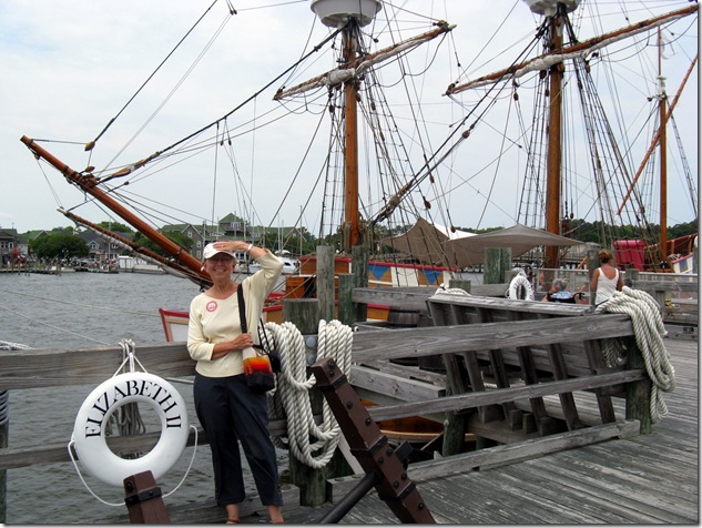
The Island today sports Festival Park, devoted to recreations of life in those colonial times.  It features the Elizabeth II, a composite replica of the type of merchant ship used by Raleigh to transport his 1585 stalwarts.  It’s remarkably small, and belowdecks was pretty crowded with equipment, like this windlass for raising the anchors and other tasks.  The voyagers

IMG_2791

slept on any available surface, here and on deck.  Can’t imagine spending months like this, although I suppose life on a submarine isn’t a lot more spacious.  Apparently, colorful paint schemes were the order of the day for these craft:
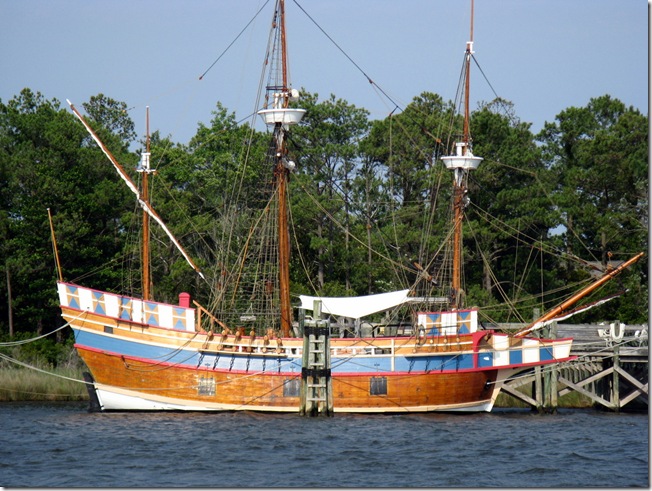
IMG_2806 

We wandered through the period village where those creepy folks who pretend they’re from the 16th century interact with you.  Always makes my skin crawl.  They were demonstrating the construction of a dugout canoe, which involves burning out the interior of a log:
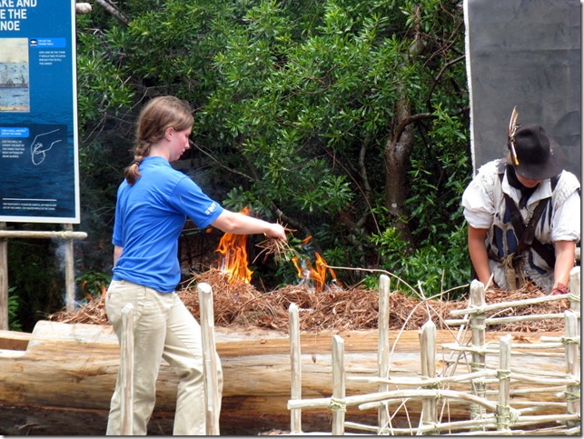
IMG_2795

 Creepy person on the right; ordinary park staff pyrotechnician spreading the fuel.  A lively blaze lasted about two minutes, then it was down to embers and smoke.  We moved on the the various village establishments, watched a blacksmithing demo, and tried out the foot-treadle lathe to turn a piece of wood.
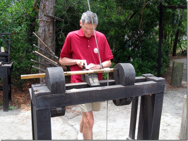
IMG_2799

It works, but I think the cutting tool actually dated from 1587.  Dull, dull, dull.

We then took off on the scoot to visit “Fort” Raleigh.  Eagle-eyed readers will note the use of quote marks around the “Fort.”  I don’t know what we were expecting of a national historic site, but it wasn’t this:

IMG_2804

Yup, that’s it.  An irregularly shaped earth berm.  They plant a flag in the center to let you know that “X” marks the spot.  Originally, of course, the fort had post walls, buildings, etc.  But all that was destroyed eons ago.  So this is all that is left, and even the berms aren’t original, they are reconstructed from some old drawing.  My question:  why bother?  Can you believe that there are National Parks Rangers who actually have been stationed here for many, many years?  I can.  We listened to one describe this site, and I think he’s in bad need of a transfer.  Think Tim Conway on speed.

Our final dose of history was to buy tickets for the evening’s performance of “The Lost Colony,” a play about the 1587 bunch that has been running since 1937!  You see, after the expedition leader (not Raleigh; the Queen wouldn’t let him go himself) dropped off the colonists, he returned to England to secure provisions and supplies.  However, the war with Spain and dealing with the Spanish Armada prevented his return until 1590, when he found the colonists had vanished.  He spent years trying to run down rumors posited by the indigino’s, but he never established what happened to them.  Hence, the “Lost Colony,” and fodder for the North Carolina tourist trade.  The play is done outside:

IMG_2805

We had third row seats, so had closeups of the cast, which numbered at least 60!  Fortunately, there was a good audience to outnumber them.  The play is entertaining, but won’t be making it to Broadway (or Peoria) anytime, ever.  We had a good time, but our standards are quite plebian.  The best thing for me was the masts and sails of the ship, that went from left to right behind the wall as if sailing off.  Great stage effect. They didn’t allow photography at the performance, so you’ll just have to imagine Indians and colonists bursting into song.  Given the hardships they were enduring (like starvation), God knows why.

The most exciting part of the evening was the 15 mile ride back to camp.  It’s pitch black on the Banks, and a screaming crosswind threatened to send us to the same fate as the colonists.  It was the most frightening ride we’ve ever done.

Saturday, June 12, 2010

A RIDDLE WRAPPED IN AN

IMG_2771

Say, what?  Stay tuned.

Our second day we decided to take the scoot south along the Banks to the 1870 Cape Hatteras lighthouse and the Graveyard of the Atlantic Museum.  The lighthouse is the tallest brick one in the country, at 208 feet, and sports a distinctive spiral pattern.

IMG_2770

There are 257 steps to the top.  This was the first.  Sure, she’s smiling now.

IMG_2762

A (ahem) few stops later, we got a great view from the top of the coastIMG_2769

and of the original keepers’ houses.  Hey, she’s still smiling!

IMG_2768

The Banks are, of course, barrier islands, and take the brunt of the open sea.  There is constant erosion and replacement going on.  The lighthouse originally was a half mile further east, but in 1999 was moved (intact!) inland that distance to put it on safer ground.  Below is a shot of the original site – the sandy area at the end of the cleared ground.  Back in 1870, that location was itself a half mile from the ocean.

IMG_2766

OK, to get back to the title, der riddle vas wrapped in an

IMG_2772

Being a fan of spy novels, seeing an actual Enigma machine was pretty neat, although I have to say it’s not much to look at.  Unfortunately, it was the best part of this “museum,” which very much is a local, low-budget effort.  There was hardly anything else to see, and the free admission was just about the right price.  Don’t make a special trip for this one.  As we left the museum, the sky had changed quite a bit, and we were facing a 40 mile ride back to camp.  Note the elevated beach houses that front the ocean.

IMG_2775

We didn’t get very far before the skies opened up with a vengeance, and the wind started howling.  This is a no go for the scoot.  I couldn’t see a thing, we were getting drenched, and we were in danger of skidding or getting blown over.  Luckily, we were near a line of houses that had carports, so we pulled over and into one that looked unoccupied, and waited out the storm.

IMG_2777

I kept wondering who put the trash cans out and whether they’d come home to find us lurking in their garage, but no one did.  Some of these beach houses are bizarre in their styling, and they all sit high on stilts.

IMG_2776

The rain slowed enough that we could proceed with caution, although I kept thinking about the “smooth” tread pattern (or lack thereof) that the scoot sports.  Not the best thing for riding in the wet.  We made it back without any real drama, but it was exhausting.  Ahhhh.  Just don’t put a white lily in my hands.

IMG_2781

Friday, June 11, 2010

THEY CAME FOR THE WIND

IMG_2753

and Wilbur and Orville found it, as did we.  But I get ahead of myself.  We made our way to the Outer Banks and the Cape Hatteras National Seashore.  We entered via the bridges to the north, at Nag’s Head, then went south about ten miles along the island to the Oregon Inlet campground of the NPS.  Again, no hookups, but there were flush bathrooms and little cold-shower outhouses.  All the comforts.  The park doesn’t have any beach views as it is shielded from the ocean by the sand dunes, but it was just fine.

We had tanked up on water at Pettigrew and our waste tanks were low, so we were set for 3 days of dry camping.  I was eager to see how well our solar panel recharged the batteries now that I reset the float level lower (~13.65V vs the “super boost” 14.6 that the factory uses).  I was afraid the constant higher boost was cooking the batteries, which would cause premature failure.  With watching TV and viewing a video, and normal lights use, we did just fine.  Of course, we’re at the seashore (no tree shadows) and the sun is almost at its maximum height, so all conditions were optimal.  Except for the clouds and rain.  More on that later.  That’s the bridge connecting ours with the 

IMG_2782

next island in the Banks’ chain.  The place was only about 15% occupied, so we had some space between ourselves and our nearest neighbors.  Not enough, as it turned out.  There was a large tent, with nobody around when we pulled in and set up.  They returned about 8:00 that evening; four guys and two girls, early 20’s.  It’s still plenty light out at 8 at this time of year.  One of the guys simply turned away from his friends and proceeded to piss on the ground almost facing us.  One of the longest pees on record.  They must have been out having more than a few brews.  One of the girls was a shriek-laugher, and she kept that up until about midnight.  Fun and games at the seashore.  Fortunately, the wind came up and helped drown out the party.  Even more fortunately, the wind really howled the next night, nearly blowing their tent away, and we heard no merriment.

We headed north to Kill Devil Hill, just south of the hamlet of Kitty Hawk.  It was at the Hill that they made their flight, but stayed in a private home in KH during their first stay testing their gliders.  The monument is quite good, and a must-see if in the area.  The Hill is where they launched their gliders, and it more or less remains today.  Atop it is a huge concrete monument to the brothers and the birth of flight.

IMG_2747

IMG_2748

The powered flights did not take off from the hill, but rather from a flat field at its base.  My finger points more or less at the end of the flight path of the fourth flight that took place that day.

IMG_2751

There were four flights.  Orville took the first, and went a grand total of 120 feet.

IMG_2754

Wilbur went next, and went about 175.  Then Orville took the third attempt and made it just a tad further.  The fourth and final was Wilbur’s, and he made a beaut at over 400 feet.  That’s the little white dot in the far distance above.  Controlled, powered flight was finally a reality.  The excellent museum on site IMG_2757 goes through the unbelievable story about how these two bicycle mechanics from Ohio analyzed the problems of flight, tested endlessly, built their own wind tunnel, corrected the wildly erroneous existing mathematical tables on various lift applications, and essentially geniused their way into their well deserved place in history.  And it all happened right where we were standing.  Very cool.